Example 1: Shape Import
This Tutorial demonstrates how to create a connected topological network of nodes and pipes in SIR 3S via the SIR 3S Toolkit based on shape data. The data used comes from ‘SIR 3S:nbsphinx-math:Modelle\Beispiele\Wasser\Manual\Projektdaten\01 Shape-Dateien’.
SIR 3S Installation
[4]:
SIR3S_SIRGRAF_DIR = r"C:\3S Consult\Sir3S-90 Entwicklerversionen\SirGraf-90-15-00-12_Quebec_x64"
Imports
Note: The SIR 3S Toolkit requires the Sir3S_Toolkit.dll included in SIR 3S installations (version Quebec and higher).
[7]:
import sir3stoolkit
The core of sir3stoolkit is a Python wrapper around basic functionality of SIR 3S, offering a low-level access to the creation, modification and simulation of SIR 3S models. In the future pure python subpackages may be added.
[9]:
from sir3stoolkit.core import wrapper
[10]:
sir3stoolkit
[10]:
<module 'sir3stoolkit' from 'C:\\Users\\aUsername.3S.000\\AppData\\Local\\anaconda3\\Lib\\site-packages\\sir3stoolkit\\__init__.py'>
The wrapper package has to be initialized with reference to a SIR 3S (SirGraf) installation.
[12]:
wrapper.Initialize_Toolkit(SIR3S_SIRGRAF_DIR)
Additional imports
[14]:
from datetime import datetime
import geopandas as gpd
import os
from shapely.geometry import LineString
import shutil
Initialization
The SIR 3S Toolkit contains two classes: SIR3S_Model (model and data) and SIR3S_View (depiction in SIR Graf). All SIR 3S Toolkit functionality is accessed via the methods of these classes.
[17]:
s3s = wrapper.SIR3S_Model()
Initialization complete
[18]:
s3s_view = wrapper.SIR3S_View()
Initialization complete
Disable additional output comments of SIR 3S Toolkit methods:
[20]:
s3s.EnableOrDisableOutputComments(outputComments=False)
s3s_view.EnableOrDisableOutputComments(outputComments=False)
Open empty model
[23]:
src = r"C:\DevOps\Github_Direct_sir3stoolkit\Test\Examples\EmptyModel.XML"
[24]:
# Generate a unique filename with timestamp
timestamp = datetime.now().strftime("%Y%m%d_%H%M%S")
dst_folder = r"C:\DevOps\Github_Direct_sir3stoolkit\Test\Examples"
dst_filename = f"EmptyModelCopy_{timestamp}.XML"
dst = os.path.join(dst_folder, dst_filename)
[25]:
# Copy the file
shutil.copy2(src, dst)
[25]:
'C:\\DevOps\\Github_Direct_sir3stoolkit\\Test\\Examples\\EmptyModelCopy_20250728_141218.XML'
[27]:
# Open the copied file
s3s.OpenModelXml(dst, True)
[29]:
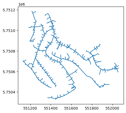
fp = r"C:\3S\Modelle\Beispiele\Wasser\Manual\Projektdaten\01 Shape-Dateien\Wassernetz_Leitungen.shp"
[30]:
gdf = gpd.read_file(fp) # Read file using gpd.read_file()
[31]:
print(gdf.info())
<class 'geopandas.geodataframe.GeoDataFrame'>
RangeIndex: 619 entries, 0 to 618
Data columns (total 9 columns):
 #   Column      Non-Null Count  Dtype
---  ------      --------------  -----
 0   3SPK        619 non-null    object
 1   TYPE        619 non-null    object
 2   _FROM       619 non-null    object
 3   _TO         619 non-null    object
 4   IDREFERENZ  619 non-null    object
 5   DN          619 non-null    object
 6   L           619 non-null    float64
 7   MAT         619 non-null    object
 8   geometry    619 non-null    geometry
dtypes: float64(1), geometry(1), object(7)
memory usage: 43.7+ KB
None
[32]:
gdf.plot()
[32]:
<Axes: >
Add Topology to SIR 3S
[35]:
dictionaryNodes = {}
[36]:
count = 0
[37]:
for index, row in gdf.iterrows():
    geometry = row['geometry']
    coords = [(coords) for coords in list(row['geometry'].coords)]
    first_coord, last_coord = [ coords[i] for i in (0, -1) ]
    key = first_coord
    if not key in dictionaryNodes:
        count = count +1
        dictionaryNodes[key] = count

    key = last_coord
    if not key in dictionaryNodes:
        count = count +1
        dictionaryNodes[key] = count
[39]:
dicNodes2 = {}
[40]:
s3s.StartTransaction("Add Nodes")
[41]:
for key in dictionaryNodes:
    Id = str(dictionaryNodes[key])
    text = str(key)
    coor = text.split(',')
    x = float(coor[0].replace('(',''))
    y = float(coor[1])
    z = float(coor[2].replace(')',''))
    Tk = s3s.AddNewNode("-1", Id, "QKON", x, y,z,0, 1, Id, Id, 0)
    dicNodes2[key] = Tk
[42]:
s3s.EndTransaction()
[44]:
s3s.StartTransaction("Add Pipes")
[45]:
for index, row in gdf.iterrows():
    geometry = row['geometry']
    coords = [(coords) for coords in list(row['geometry'].coords)]
    first_coord, last_coord = [ coords[i] for i in (0, -1) ]
    fromNode = toNode = "-1"
    mat = str(row["MAT"])
    DN = str(row["DN"])
    IdRef = row["IDREFERENZ"]

    if first_coord in dicNodes2:
        fromNode = dicNodes2[first_coord]
    if last_coord in dicNodes2:
        toNode = dicNodes2[last_coord]

    lines = [xy[:2] for xy in list(geometry.coords)]
    new_p = LineString(lines)

    s3s.AddNewPipe("-1", fromNode, toNode, float(row["L"]), str(new_p), mat, DN, 0.25, IdRef, row["TYPE"], 0)
[46]:
s3s.EndTransaction()
Save changes
[48]:
s3s.SaveChanges()
…